Saturday, October 14, 2023

Rocky Peak and Giant Mountain, October 10, 2023, Giant Mountain Wilderness, Adirondack Park

View from Rocky Peak summit to Bald Peak, Lake Champlain and Green Mtns.

I lucked out and found a sleeping giant.

In all these years of hiking the High Peaks, I can't remember ever once driving by the Giant Ridge Trail/Chapel Pond parking areas on Route 73 and seeing fewer than a dozen cars and an equal number of hikers anxiously milling about in preparation for their big outings. Imagine my surprise when, on a Tuesday after the Columbus Day long weekend, I found myself pulling up to these parking areas and finding them completely empty. Score. Indeed, I wound up having the super-popular Giant Ridge Trail all to myself for almost an entire day.
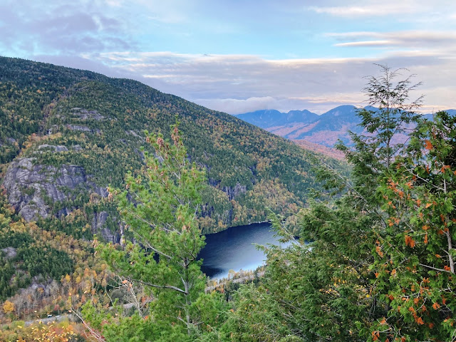
First vista point, view to Chapel Pond and Giant Ridge Trail parking

I hit the trail at 7 a.m. sharp and made quick work of the first section of the trail - the switchback climb of some 600 feet of gain up to the Chapel Pond overlook. The usually-dry stream was raging from the weekend's heavy rains, but the crossings were still easy. It's neat to be able to look down on the pond and see your car as a tiny speck far below. 

Noonmark and Great Range from Giant Ridge Trail above Washbowl

It's easy to see why Giant Ridge Trail is so popular. There are lots of switchbacks along the route, which eases the significant gain over such a short mileage. But it is still up up up up up from the get go. Towards to top, the trail leaves the woods and follows a series of open rock ledges which were stripped of their vegetation by a forest fire years ago. When ascending, you really don't get the full visual effect as your eyes are on the trail ahead and your mind on the workout to get to the summits. But when descending, the trail on these ledges rewards you with a wide, sweeping panorama of the full High Peaks from the Dix Range to the Great Range. It's got to be one of the best views in the ADK.

View to Rocky Peak from Giant shoulder

The most difficult part of this hike was the drop into the col between Giant and Rocky Peak. It's a steep, knee-breaking descent and, of course, has to be reclimbed after visiting Rocky. The solace, I suppose, is that once you are in the col, the climb up to Rocky Peak is at moderate grade and quite easy. To ease the burden even more, I stowed my heavy pack and went up with just minimal gear. As expected, the views from Rocky Peak were amazing as well. The high winds prevented a long stay, so I soon descended, took a lunch break in the col (out of the wind), and then made the slog-of-a-climb back up the Giant. I made sure to pay a quick visit to the summit, too, which is just a few hundred yards from the junction.

Moderate grade trail to Rocky Peak summit

I saw my first hikers of the day once I was back on Giant and preparing to descend. First it was a solo hiker. Then a second soloist. Then a group of two with a dog. And then a family of four (without packs or water). Then another group and another and another. It was trail congestion central for a short span of time and I had to keep pausing to let people ascend - good naturedly, of course, and I even chatted with a few. Fortunately, once I passed the intersection with the Roaring Brook Trail, it got very quiet again and I didn't see any other hikers for the remainder of the day.

View of Dix Range and Round Pond from Giant Ridge Trail

I was back to my car at 1:00 p.m. for a total trail time of six hours. As expected, the parking areas were full.

Peaks: Rocky Peak and Giant Mountain
Elevation: 4,420 feet and 4,626 feet (Gain: 4,238 feet)
Distance: 7.3 miles roundtrip
Route: Out and Back: Giant Ridge Trail to East Trail
Conditions: Partly sunny, 30 degrees F


Friday, October 13, 2023

Noonmark Mountain, October 13, 2024, Eastern High Peaks, Adirondack Park

View to the Great Range from Noonmark Summit

I call them "morning mountains." These are those lower-elevation, but equally-rewarding, peak hikes that you find all throughout the Adirondacks. You know the ones to which I am referring... Rooster Comb, Catamount, etc. These are attractive for many reasons. For one, you can get up and back in a relatively short span of time. Hence, they are perfect for a day when you just have a morning free for a hike but stuff to do in the afternoons. Morning mountains are also a great alternative when the National Weather Service Mountain Points Forecast calls for the highest summits being in the clouds.  On days when the 46ers are socked in, I often choose to do a morning mountain hike instead since you still get a view at the end of the climb  - a view that often involves looking up to the higher summits covered by the clouds.

Pleasant wooded climb on Stimson Trail to Noonmark

On this particularly day, I decided on Noonmark. It's fairly well known and popular due to the fact that you can see it so clearly from the main street in Keene, rising pointedly into the sky and marking the hour of noon at midday. Noonmark, of course, is also the namesake of the town's famous diner. Despite its prominence and popularity, the peak does keep some folks away because it is quite rugged towards the top. You can access the peak from the north via the Round Pond parking area but the more popular route is from the south via the Stimson Trail out of the AMR. 

Panorama from Noonmark

I chose the latter. Fortunately, I was able to grab an online reservation on short notice. Usually, all those reservations get booked up weeks in advance. I really lucked out as someone must have put in a cancellation due to the iffy weather. Man, I really miss the old days before the reservation system. It should be first come, first serve. That's always been the rule of trail parking. Making an online reservation blows.

View up to Noonmark summit from lower ledges

From the parking, I made my way up the paved round to the golf course, turned left through the AMR bungalows, and then started the pleasant, uphill climb accompanied by the sights of falling leaves and the sounds of Icy Brook, a tributary of the Ausable River. As you make your way up, this trail leads over a lot of open, rocky ledges with views in multiple directions. These make great alternative break points on days when the summit is overcrowded, but I decided to just push on to the peak. I made it to the top in one hour and fifteen minutes. Since it was still early, I had the summit all to myself and took a while to relax and admire the view across the valley to the 46ers of the Great Range and the cloud cover that enshrouded their summits.

A morning mountain was definitely the way to go. 

Peaks: Noonmark Mountain
Elevation: 3,556 feet (Gain: 2,175 feet)
Distance: 4.2 miles roundtrip
Route: Out and Back: Stimson Trail
Conditions: Partly sunny, 35 degrees F


Saturday, September 16, 2023

Mount Eisenhower and Mount Pierce, September 15, 2023, Southern Presidential Range, White Mountain National Forest

Panorama from Mt. Eisenhower Summit

On a Friday with a decent forecast following a week of unsettled weather and summits in the clouds, I decided against my original plan of hiking up to my favorite Presidential peak -- Mount Jefferson. I knew that there would be way too many people for my liking up on the big guys. But since it had been a while since I'd been on the Presidentials, I really wanted to pay my respects. So ultimately I decided that Mount Eisenhower via the lesser-traveled Edmands Path would get me where I wanted to go while also providing a better chance for some peace and tranquility while getting there. 

Eisenhower Loop Trail

Edmands Path, I think, is the best approach to Eisenhower. Named for the revered trail builder, the path meanders its way up the north side of Eisenhower, taking care to follow the best grades for sure footing the whole way up. It's long, rocky, and steep - as one might expect in the Whites - but it is clear how much thought the trail builder put into his project. The extensive, hand-built rock cribbing that still supports the trail a century later is a further testament to his diligent efforts.

View from Eisenhower Summit to Mt. Washington

In order to avoid a shorter up and back, I decided to turn the hike into a 10+ mile loop hike over both Eisenhower and Pierce and a return via the more-popular Crawford Path and a 2 mile road walk on Mt. Clinton Road back to the car park. I made quick work of Edmands Path thanks to the quality of the trail. After a few minutes on the loop trail up to the summit, I had the pleasure of having Ike all to myself for my first trail break of the morning, even if I needed to put on my winter garb due to the cool autumn temps and brisk, bone-chilling winds. I wish I could have hung out longer, but it was COLD.

Neat Alpine Zone Veg

Once off the notoriously-exposed summit, the wind and cold subsided and the hiking conditions were absolutely perfect. I only passed a couple of hikers on my way over to Pierce and then made the knee-breaking descent to Mizpah to fill up my water. After that, I took the cutoff down to Crawford Path for the rest of my descent. As expected, this is where my quiet, peaceful morning turned into congestion central with numerous parties heading up as my day was nearing its end. 

Gibbs Falls

I took my final trail break at the pretty Gibbs Falls. Most folks on their way up blow by the spur trail to the falls since they are intent on the many miles and elevation gain ahead and don't want to waste any time. Therefore, I had the place all to myself and stayed long enough to enjoy the tumbling waterfall and recharge for the roadside hike on Mt. Clinton Road back to my car. The narrow road is in terrible shape for auto traffic with overgrown foliage on blind curves, frost heaves, pot holes and crumbling asphalt. But it winds its way pleasantly through the deep woods and actually made for some nice walking to round out the day. As long as you watch out for any speeding A-holes in Jeeps.

Crawford Path marker

My overall timing, it must be said, was absolutely perfect. Just as I was driving past the winter gate to get off Mt. Clinton Road, an F150 with Texas plates pulling a 30-foot camper was about to take his monstrosity up that tiny road. If Mr. Everything's-Bigger-in-Texas went through with his stupid plan and got stuck, there would be absolutely no way for him to turn around. Further, any vehicles coming down the road from the trailhead parking would have no way to pass him. Had I gotten off the trail ten minutes later, I might have been stuck up there for hours.

Always some kind of drama in ever-popular Crawford Notch.

Peaks: Mt. Eisenhower Mount Pierce
Elevation: 4,760 and 4,312 feet feet (Gain: 2,950 feet)
Distance: 10.5 miles
Route: Loop: Edmands Path to Mt. Eisenhower Loop to Crawford Path to Webster Jackson Cliff Trail to Mizpah Cutoff to Crawford Path to Mt. Clinton Road
Conditions: Fog to mostly sunny, 55 degrees F