Friday, October 16, 2020

Catamount, October 15, 2020, Taylor Pond Wild Forest, Adirondack Park

View of Silver Lake from Catamount Summit

I needed two days of rest after completing a 19-mile, single day loop of Gray, Skylight and Marcy. After two days off, my plan was to tackle another couple of High Peaks before heading home. Although the precip and temp forecasts for the day were perfect, there was a high wind warning with gusts in the  higher summits predicted as upwards of 75 mph. I don't mess with high winds above tree line, so I bailed on my plan and figured I would use the day to visit a lower peak that had long been on my to-do list -- Catamount. 

Catamount Approach

Catamount is in the Taylor Pond Wild Forest, just south of both Taylor Pond and Silver Lake. The Silver Lake Bog Preserve has long been a favorite short hike for K and me, so I was looking forward to getting a birds eye view of it from the Catamount summit. I also remembered reading a past issue of ADK Mountain Club's magazine that had short bios of people running as club officers. One candidate had listed Catamount as their favorite hike in the ENTIRE Adirondack Park. I always found that curious and wanted to see what Catamount was really all about.

View of Catamount from False Summit

As it turned out, that person was spot on. Catamount is a great little hike. It is short - just under 4 miles round trip - but in those few short miles it packs all the features of a classic ADK hike - open ledges, boulder scrambles, a "chimney" climb, remarkable 360-degree vistas from the 3,000 foot summit, and, as expected, a nice view down onto Silver Lake. 

Descending the Catamount Ledges

Despite the short distance and modest, 1,500-foot elevation gain, Catamount is not to be underestimated. It's not marked very well and there is potential to get lost on the ledges, especially when descending. And the boulder scrambles can be dangerous when it's wet or icy. The high wind forecast proved correct as I hit some serious gusts on the ledges and summit. I only managed to stay on top for a few minutes and quickly started my descent, thankful that I wasn't bopping around the High Peaks in that nastiness.

Peak: Catamount
Elevation: 3,169 feet (Gain: 1,571 feet)
Distance: 3.6 miles
Route: Up and Back, Catamount Trail
Conditions: High Winds, Partly Sunny, 35 degrees F

Wednesday, October 14, 2020

Gray Peak, Mt. Skylight and Mt. Marcy, October 12, 2020, Eastern High Peaks, Adirondack Park

Summit Approach, Mount Skylight

By many people's standards, Mount Marcy is THE ONE. For 46er aspirants, it's often the final peak on their lists. For many first time hikers, Marcy is the first and only high peak they ever want to do. It's a summit that one never has all to oneself, even at dawn, because people like to hike through the night and see sunrise from the highest mountain in New York State. It's the peak where there are often actual parties on top, complete with music, six packs of beer, drones, juggling sticks, and even hula hoops. All true.

So for me, Marcy has never been a preferred destination. And, as it turned out, I finally climbed Mt. Marcy simply as a way to get home from a much more pleasurable peak, Mount Skylight.

Lake Tear of the Clouds

I arrived at the Adirondack Loj parking area at 5:40 a.m. Since it was Columbus Day, a good number of hikers were also setting off on their holiday hikes. I grabbed my envelope, parked, and then walked over to drop my payment, losing a few minutes playing gate attendant for a few bewildered first timers who didn't know the parking payment protocol. I really hate hiking out from the Loj due to the sheer numbers of people, especially when they are all wearing ultra-bright headlamps, yapping, and banging around in the pre-dawn hours. Morning hiking is supposed to be quiet and peaceful.

View of Skylight from Gray Peak Herd Path

Once underway, I did the easy miles to the Dam by headlamp and then pressed onwards and upwards past Lake Arnold. My plan was an out and back to Gray and Skylight, accessing both peaks via the trial that runs alongside Feldspar Brook. Once past the Dam, I had the trail all to myself until finally encountering the first hikers of the day near the famous "floating bridges" -- partially submerged logs that are supposed to help with crossing a deep bog. Those "bridges" turned out to be nothing of the sort and I had to avoid them altogether by following a partially-hidden bushwhack trail that negotiated around the bogs. This section really needs some trail maintenance.

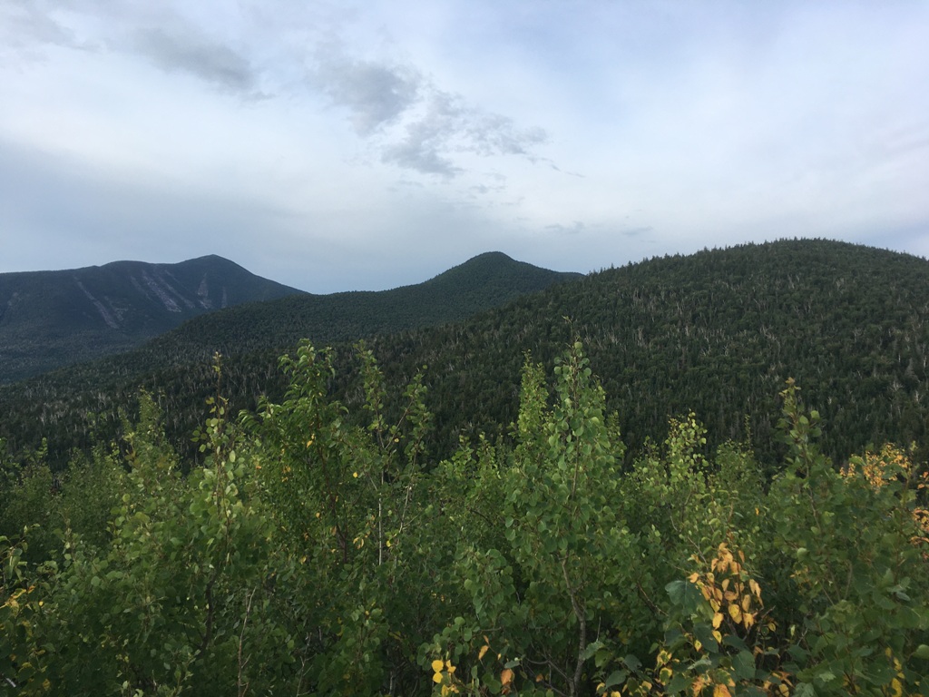
View to Mt. Marcy from Mount Skylight Summit

After the bushwhack, I worked my way up the pretty trail that follows Feldspar Brook up to Lake Tear of the Clouds. The lake is notable as being the highest source of the Hudson River. It is also famous for being where Vice President Teddy Roosevelt was hiking when he first learned that President William McKinley was not going to survive an assassin's bullet. Roosevelt was soon after sworn in as president when McKinley died. Pretty neat tidbit of New York and presidential history.

Trail Break, Approach of Marcy from Four Corners

More importantly, Lake Tear of the Clouds is where the unmarked "herd path" to Gray Peak begins. I did the quick up and back not expecting much, but I was pleasantly surprised by some of the technical challenges of the trail and the partial views from the mountain. I then moved on to the Four Corners intersection and took the marked trail south to Mount Skylight. With its above-tree line approach, lack of heavy hiker traffic, and fabulous, 360 degree views, Skylight was the absolute highlight of the day and one of my favorite of the high peaks.

Mount Marcy Summit

It was during a long break on Skylight that I looked over my maps and decided that I would head back to the Loj by going up and over Mt. Marcy instead of retracing my route. (BTW, When hiking solo in the backcountry, I always leave my route with K and this alternate return route was in the notes I left behind with her). The climb up Marcy from the south is long, steep, and across open rock, but it's fairly straightforward with no hand-over-hand boulder scrambles. Halfway up Marcy, the rigors of climbing a pair of 46ers and working on a third finally began to take its toll. I forced myself to take another break at the Panther Gorge overlook in order to recover and regain the energy needed for the final summit push. Indeed, there are great views the whole way up and I found myself stopping quite often to turn around and catch some vistas. I can see why people often prefer to descend this way.

Autumn on the Van Ho Descent from Marcy

Needless to say, the Mount Marcy summit itself also offers amazing views. But for me, the whole experience was somewhat ho-hum. I took a couple of pictures but didn't even stop for a break or to chat with the other hikers. Instead, I quickly started the long, seven mile return to the Loj via the Van Ho trail. Notorious for being packed with hikers, I fortunately only encountered a few people along the entire route -- most of them in the log jam between Marcy Dam and the Loj. I was back to the car at 4:30 p.m., clocking a 10.5 hour day of trail time, 19 miles of distance, and more than 5,000 feet of elevation gain. 

It wasn't until later that I realized that Marcy was my 23rd peak on the Forty-Sixer list. Halfway. I guess Marcy has some meaning after all.

Peak: Gray Peak, Mount Skylight, Mount Marcy
Elevation: 4.840 feet, 4,926 feet, and 5,344 feet (Gain: 5,000 feet)
Distance: 19 miles
Route: Loop, ADL Loj, to Marcy Dam, to Lake Arnold, to Feldspar Brook, to Gray Peak herd path, to Four Corners, to Mt. Skylight, to Mount Marcy, return via Van Ho Trail to Loj.
Conditions: Sunny, 35 degrees F., some icy spots on Skylight and Marcy.

Sunday, September 20, 2020

The Owl, September 18, 2020, Baxter State Park, Maine


View from the Balancing Boulder, The Owl Summit Cone

Katahdin means "Greatest Mountain." But I'm renaming it "Decoy Mountain." We only had one day set aside for hiking in Baxter State Park and it turned out to be a banner, blue bird day of absolutely perfect hiking weather. Since we can't stand being around hoards of people when hiking, we theorized that Katahdin would be a good decoy. Since EVERYONE would be up there, we'd have a neighboring mountain called The Owl all to ourselves.

We were right.

First View of the Owl Summit

We arrived at the gatehouse at 7 a.m. and sat in a jam of 20 or so cars waiting to get inside. We almost turned around in frustration, but stuck in our and got a parking space at Katahdin Stream Campground. We started off on the Hunt Trail to Katahdin and, of course, saw a bunch of hiking parties. But one mile in, the Owl Trail branches off to the north. From that point until the end of the day, we only saw a single hiker.

Topping the Owl

The Owl Trail is an excellent trail leading to an awesome mountain. It starts with a steady climb through a mossy forest along the banks of a small tributary of Katahdin Stream. After crossing it - the last water source - the trail heads up the ridgeline until popping out of the trees below the summit cone, which supposedly resembles the form of a Great Horned Owl. The summit climb first emerges at a precariously balanced boulder, with the first great views of the ridge below and Katahdin to the east. Rock scrambles then bring you out onto a wide open expanses with a large rock cairn. This is the best place for a a long break, but the true summit is a little further on, with no additional gain needed to reach it.

Descending from the Owl Summit

Peak: The Owl
Elevation: 3,736 feet (2,571 feet Gain)
Distance: 7 miles
Route: Out and back, The Owl Trail
Conditions: Sunny, 40 degrees F


Saturday, September 19, 2020

Rainbow Ledges and Loop Trail, September 17, 2020, Debsconeag Lakes Wilderness Area, Maine


The APCs with Katahdin in Distance, from Rainbow Ledges

On a recent long weekend jaunt up to Maine, my brother, nephew and I chose to do a short loop hike in the Debsconeag Lakes Wilderness as a warm up hike before a bigger outing in Baxter State Park. I don't get to Maine too often. But my brother needed to pick up a Grand Laker canoe that he had purchased for restoration and we decided to turn it into a hiking trip. We booked a cabin on South Twin Lake just south of Millinocket as our base of operations.

Dawn at the Cabin on South Twin Lake

The Debsconeag was an appropriate choice for a hiking trip tied to a canoe pickup -- the Indian word means "Carrying Place," a name bestowed on the area because of the many lakes and ponds requiring portages between them. It's a fabulous place to hike, off the beaten path and devoid of the hoards that we expected to see in Baxter State Park the next day. We had the hike pretty much to ourselves with the exception of a couple of campers in the backcountry and a part of three in the parking lot as we were leaving. 

Confusing Trail Sign at Rainbow Pond Parking Area

The trails aren't really named very well and the signage is confusing, but we had the AMC Maine Mountains map and knew how to tackle it. It is basically a loop with an optional out and back spur to Rainbow Pond at the end. We did the hike in a counter clockwise direction, with the first destination being Horserace Pond. The trail has the pleasant sound of Horserace Brook all the way to the pond, which is a spectacular place. We pulled a "leaner" on some slanted boulders on the southern shore for a nice late morning coffee break. 

Horserace Pond

After the pond, the trail makes a long but easy climb to the Rainbow Ledges, which offer great views to Kathadin in the distance and the many water bodies that gave the Debsconeag its name. We took a second break on the ledges and then undertook a long descent back into the valley, happy to have found a lesser trafficked trail that definitely deserves another visit.

Peak: Rainbow Ledges
Elevation: 1,504 feet
Distance: 6 miles
Route: Loop, Horserace Brook Trail; Outlook Trail, Blue Trail
Conditions: Partly sunny, 60 degrees F

Wednesday, September 2, 2020

Street and Nye, Eastern High Peaks, Adirondack Park, September 1, 2020

Mossy Forest on Summit of Street

Sometimes, I don't get Adirondack hikers. Tons of trip reports call Street and Nye a "good, bad weather hike." But the same writers also complain about the mud and muck on the unmarked, unmaintained trail that takes you there. 

If you don't like getting your boots dirty, then don't do Street and Nye on a shitty day.

I hadn't planned it that way, but it turned out that the day that I chose to do Street and Nye wouldn't be a banner, blue bird day. It was blustery and slightly overcast with intermittent drizzle. I knew that it would be wet and muddy but just embraced that fact from the get-go. Mud doesn't bother me, nor does a lack of views - that other complaint about Street and Nye. The fun isn't always the destination, it is the trip getting there.
Crossing Indian Brook in Headlamp Light

I set out at 5:30 a.m. and did the first section of the trail around Heart Lake and all the way to the Indian Brook crossing with the light of a headlamp. The brook was at its late summer low levels and the crossing was no problem. The trail from there up to the col between Street and Nye is quite pleasant since you get the sounds of a stream for much of the way. At multiple points, the trail becomes the stream bed and this, I suppose, is part of the reason for its muddy reputation. Although not maintained, the trail is easy to follow if you are paying attention. I repaired a few fallen cairns here and there at the tricky parts. It can be confusing at the brook crossing since there are multiple crossing points and I got off track on the return because of this, but my map and compass quickly fixed the problem.
First views of the day, to the east, from the climb to Street and Nye

At the col, the trail splits in a pleasant break spot marked by a small cairn. I did the longer trek over to Street Mountain first and saved the quick up and back to Nye for last. The trail over to Street is absolutely gorgeous. It was covered in moss and lichen that turned the forest into a sparking green wonderland whenever the sun started to peak through the cloud cover. The wet conditions for which these mountains are known produce a lot of mud and muck, for sure, but it is counterbalanced by the water-loving flora that make this trail so special.
The Trail Split, South to Street, North to Nye

It was a little eerie up top since I was totally along the entire time with the only sounds being the blustery winds whipping through the conifers. I hardly took a break, just hit the peaks, packed up and headed back down. I encountered only six people during my descent and was back to the Loj parking area at 10:30 a.m., for a quick up and back trail time of 5 hours sharp.
Pleasant Forested Summit on Street

My boots were mud encrusted and my pant legs brown and soggy, but I was already planning to make another visit to Street and Nye on a nice weather day. 

It's actually a great hike and deserves better reviews than just "save it for a crappy day."

Peaks: Street and Nye
Elevation: 4,166 and 3,895 feet (2,634 feet Gain)
Distance: 9.1 miles
Route: Out and back
Conditions: Overcast, wind, drizzle, 55 degrees F

Tuesday, September 1, 2020

Sawteeth, Gothics (and Pyramid), August 31, 2020, Eastern High Peaks, Adirondack Park

Lower Ausable Lake from Scenic Trail to Sawteeth

The Sawteeth seem to get zero respect. Most people seem to treat them as an "add on" on rather than a destination, probably because they so easily reached via a short spur from the Weld trail and most hikers just quickly grab the summit as part of a loop over Gothics and Armstrong. And since the views are not the 360 degree ones you get on nearby Pyramid Peak or from the open ridge of Gothics, people seem to disparage the actual Sawteeth summit as "meh." 

But Sawteeth are actually one of the absolute best hikes in all of the Adirondacks if you incorporate the Scenic Trail as part of your itinerary. It's a long, winding, out of the way route that the everyday aspiring 46er won't even consider -- they often seem to be too obsessed with finishing their list as quickly as possible. Fine by me. Means I get one of the best trails in the High Peaks all to myself.

Dam at Lower Ausable Lake, start of A.W. Weld Trail

I pretty much had just that on a beautiful late summer day with little cloud cover and no wind - the kind of day when the parking lot at the AMR is filled up by 6 a.m. I decided to do a Sawteeth loop hike with an out and back to Pyramid and Gothics and got to the parking lot by 5:30 a.m., geared up, and was on the trail at 5:45 sharp. I used the Lake Road to do easy-on-the-legs miles up to the dam. The AMR gatekeeper passed me twice on a golf cart, once going up, and once going down, sharing a friendly "You have it all to yourself!" shout out to me as he headed back to his hut.

View back to Pyramid Peak from Gothics Shoulder

He was right. I didn't see a soul for hours. I was alone for the entire ascent up the Weld Trail, including the always-popular Rainbow Falls. I was alone during a long break on the summit of Pyramid Peak, enjoying what some say is the greatest view in all of the ADKs. I then did a quick out and back over to the summit of Gothics and had that entire jaunt, as well as another short break on the Gothics summit boulder, all to myself as well. I finally saw the first hikers of the day when I retraced my route back to Pyramid Peak. Several people had come up in the time I was over at Gothics and were taking a break on the summit.

View of Marcy from Sawteeth Summit

From there, I headed back down to the col between Pyramid and Sawteeth and made the climb to the Sawteeth summit. There, I ran into a couple of aspiring 46ers and their border collie. They were friendly and quick to share the fact that they weren't  impressed with the summit. We talked for 5-10 minutes and then they started out on their long trek back to the Garden parking area, cursing the NO DOGS ALLOWED rule that prevented them from coming in from the AMR.

Ladder on Scenic Trail

But the absolute best part of the day was the amazing descent from Sawteeth via the Scenic Trail. This trail goes right through the "teeth," those rocky vertical slabs that you can see from various points in the valley that give the peak its name. The trail is pretty much all vertical, with wooden ladders needed to negotiate some particularly harrowing precipices. All along the way, you come to various rocky outcroppings that overlook Lower Ausable Lake. At the first outlook on the descent, the lake is straight down, more than 1,000 feet below -- A pretty daunting sight when you know that the trail you are on is going to take you there. I took several breaks along the way, admiring the views of the lake from the various outlook points, and even had the chance to listen to the calls of a common loon as I got closer to the water's edge. Once it makes its way down to the lake, the trail pleasantly meanders right along the water's edge and back to the dam. 

Although it was early afternoon on an absolutely perfect hiking day in late summer, I encountered only one hiker on the Scenic Trail in the three miles between the summit and the dam. 

If ever there was an overlooked, "sleeper" hike in the ADK, the Scenic Trail is it.

Peaks: Gothics and Sawteeth (via Pyramid)
Elevation: 4,736 and 4,100 feet (4,000 feet Gain)
Distance: 15.2 miles round trip in 9 hours 
Route: Loop combined with out-and-back, Lake Road, to A.W. Weld Trail to Pyramid and Gothics, reverse course to Trail 37 to Sawteeth, to Scenic Trail, to Lake Road.
Conditions: Sunny, 75 degrees F


Sunday, August 9, 2020

Dial and Nippletop, August 7, 2020, Eastern High Peaks, Adirondack Park

View to the North from Nippletop Summit

There are two differing opinions on how to best tackle Nippletop, that mammoth peak to the south of the Great Range with some of the most amazing views in all of the Adirondacks. Having been up at Elk Pass before, I knew that the counter clockwise loop to Nippletop is one long, unrelenting climb, with seriously steep sections from the pass itself up to the summit.

The other route, a clockwise loop using the H.G. Leach Trail, consists of a lot of ups and downs over several other peaks and smaller nubbles before you finally make the push to Nippletop. I really didn't like that super-steep climb from Elk Pass that last time I was up there, so I decided on the up-and-down clockwise loop instead.

Noonmark through the Trees

The AMR parking in St. Huberts was totally full when I rolled in a 5:20 a.m., so I got the last spot at Giant Mountain lot across the highway and hit the trail at 5:30 sharp. There were a few parties setting out with dogs and trying to determine what to do when greeted with the huge signs that prohibit them and another party of two just behind me as I moved quickly through the golf course. Fortunately, I left them behind and had the entire approach to Nippletop - 7.2 miles via the H. G. Leach trail - all to myself.

Looking ahead to all three peaks, Bear Den (right), Dial (ctr), and Nippletop (left)

As expected, there are plenty of ups and downs on the Leach trail. Leaving the gentle Lake Road, the trail does a ton of gradual gain right away and you are rewarded with a nice view through the trees of Noonmark Mountain and then a nice view ahead to all three peaks along the day's route. Nippletop, rising in the far background, is a daunting sight indeed.

It was a long day, for sure, and I needed to take short breaks on the summit of wooded Bear Den Mountain and again at the top of Dial, another 46er peak which awards a nice view north to the full majesty of the Great Range. Then I made the final up-and-down climb to Nippletop, where I needed about a half hour of recovery time before the long, steep descent. Fortunately, I had the summit all to myself.

View towards Mount Marcy from Nippletop summit rocks

Following the loop, I next descended to Elk Pass where I started to encounter a few groups heading to Nippletop. Elk Pass itself and its two little ponds was as pleasant as usual, and I took my time meandering through the area before descending via the Mt. Colvin Trail. Although I was trail weary, I decided not to take the first cut off to Lake Road, choosing instead to take the Gill Brook Trail. With its many waterfalls and flumes, Gill Brook is one of the most picturesque trails in the ADKs. It was definitely worth the extra time and effort. I was back at the parking area at 1:30 p.m. Eight hours of trail time. A big day, indeed.

Along the Gill Brook Trail

Peaks: Dial and Nippletop (via Bear Den Mountain)
Elevation: 4,020 and 4,620 feet (4,000 feet Gain)
Distance: 14.2 miles round trip
Route: Clockwise Loop, Lake Road, to Henry Goddard Leach Trail, to Mt. Colvin Trail, to Gill Brook Trail, to Lake Road.
Conditions: Sunny, 75 degrees F


Saturday, August 8, 2020

Goodnow Mountain, August 6, 2020, Long Lake Region, Adirondack Park

View from the summit cabin and fire tower on Mount Goodnow

When possible, I like to do a shorter, lower elevation peak hike the day before embarking on a Big Day in the ADK. Since I had plans for a 14 mile, 4000+ elevation trip to Nippletop and Dial the next day, I chose Mount Goodnow near Newcomb this time. I'd never hiked it before and it seemed to be the perfect length and elevation for a quick warm up hike. 

I NEVER hike in the afternoon. And since circumstances dictated that I would be hitting the trail at 2 in the afternoon, I kind of figured it would be pretty busy. But I wasn't expecting a full parking lot and a party on top. I made quick work of the 1,089 elevation gain over 2.1 miles to the summit, passing numerous large groups going up and down all along the way. I stayed at the summit for only a minute, enough to snap a quick photo of the view from the fire tower, and then got outta dodge. 

It was a nice little hike that took me exactly 1 and 1/2 hours. But I won't do it again unless it's at 6 a.m.

Peak: Goodnow Mountain
Elevation: 2,685 feet (Gain: 1,089 feet)
Distance: 4.2 miles round trip
Route: Up and back, Mount Goodnow Trail
Conditions: Sunny, 75 degrees F

Wednesday, July 8, 2020

Ganoga Glen Falls and Old Bulldozer Road Loop, July 7, 2020, Rickett's Glen State Park, Pennsylvania


Ganoga Falls
I've hiked all over Pennsylvania. The farm country of south central Pennsylvania when I lived in Lancaster and worked in Harrisburg. The woods of north central Pennsylvania when I was in school at Penn State and when visiting my brother in Lewisburg. Allegheny National Forest and all of western Pennsylvania when I lived in Pittsburgh. The Delaware Water Gap and far eastern Pennsylvania since moving to New Jersey. The one part of the state that I have never hiked is that area around Scranton and Wilkes Barre. I just NEVER go there. That's probably why I'd never once been to Rickett's Glen State Park in all my years hiking around the commonwealth.
The First of the Falls - Murray Reynolds 
My brother and I decided to meet at Rickett's Glen on a Tuesday morning as early as possible since we knew the place would be swamped. I had to leave at 4:30 a.m to make the 2 hours and 40 minute drive to the trail head... and even then, cars were rolling in at the somewhat early hour of 7 a.m. We resolved to do the heavily-trafficked waterfall trails first and then head out to the peace and quiet of the eastern reaches of the park via some less-traveled paths. Fortunately, the plan worked great and we only saw a handful of hikers around the falls and then had the rest of the day all to ourselves.
Fern Woods on Highland Trail
The falls trail really is spectacular. It's a long, steep ascent on stone steps from the trail head passing no fewer than 13 named cascades on Kitchen Creek... and that's only the western section of the hike through Ganoga Glen. The main trail that we took up from PA 118 splits at a place called "Waters Meet. We turned northwest up Ganoga Glen. The northeastern route - up Glen Leigh - has even more waterfalls. Most people do the loop of those two sections, but we opted to skip Glen Leigh altogether in order to escape the coming hoards.

The highest of the falls is the 94 foot cascade Ganoga, which is amazing in sheer height, but many of the other, smaller cascades, have a real picturesque quality about them so I actually liked them much more.
Harrison Wright Falls, just before Waters Meet
After the steep ascent of the falls trail, we looped around the north end of the park on the appropriately named Highland Trial, which follows the wooded ridge line, and then followed the long descent on the Old Bulldozer Road.

We liked the last section of the hike so much that we resolved to return to Rickett's Glen, skip the waterfalls entirely, and complete a long loop hike that would incorporate some more of those quiet, lonely trails on the east side.
Andy and Arlo at Ganoga Falls Overlook

Trail: Western Falls and Old Bulldozer Road Loop
Distance: 8.3 miles round trip
Elevation Gain: 1,315 feet
Route: Falls Trail (West branch) to Highland Trail to Mountain Springs Trail to Old Bulldozer Road
Conditions: Mostly sunny, 95 degrees F
Notable Flora and Fauna: Winter Wrens


Saturday, June 27, 2020

Thunder Swamp Trail Northeast, June 26, 2020, Delaware State Forest, Pennsylvania

Looking South from the Bridge over Little Bushkill Creek

We liked the forests of the Thunder Swamp Trail so much that we decided to return in two weeks in order to hike the northeast section of the trail. Starting at Painter Swamp, we determined that we could do a figure eight hike incorporated both the far eastern loop of the Thunder Swamp Trail and another loop north into the Stillwater Natural Area.

We met at the trail head at 7:30 a.m. and were surprised to find a car already there. Fortunately, it turned out to be a fisherman on his way home from an early morning excursion to Painter Swamp, our first landmark on the hike. It's a pretty place. We took the trail that follows the eastern shore.

Painter Swamp
Painter Swamp

After Painter Swamp, we got on the Thunder Swamp trail and followed it to its eastern most point, where it does a full loop. On the way, the trail crosses Little Bushkill Creek on a nice bridge - a perfect spot for lunch or a long break.

Bridge over Little Bushkill Creek

After the Thunder Swamp loop, we took another loop to the north through the Stillwater Natural Area - a nice section - which brought us out just north of Painter Swamp. We opted for a shortcut long the road and back to the parking area, completing a nice, peaceful 9.2 mile loop. We didn't see anyone the entire day.

Hike: Thunder Swamp Trail (Northeast Section) and Stillwater Natural Area
Distance: 9.2 miles
Route: Figure Eight, Painter Swamp East Trail, Thunder Swamp Trail, Coon Swamp Trail
Conditions: Sunny, 90 degrees F
Notable Flora and Fauna: Porcupine


Sunday, June 14, 2020

Thunder Swamp Trail Northwest, June 13, 2020, Delaware State Forest, Pennsylvania

Zoe Dog Retrieving a Stick in the Open Swamp at the Spruce Run Let Out
As soon as we got back from our hike of Fourth Run, my brother and I started checking the maps to find another location where we could meet up again. A predicted run of cool temps and sunshine expedited our efforts, and we settled on a state forest that neither of us had ever explored - Delaware State Forest, the easternmost in Pennsylvania. It is home to a long, looping trail called Thunder Swamp.

We decided on a 12 mile one way hike of the northwestern section, which would include an internal side loop of the remote Pennel Run Natural Area. We chose a Saturday due to the excellent forecast, but feared that a nice weekend day would mean mobbed trails.

Normally, we'd be on the trail at 5 a.m., but we both needed about 2 hours to drive to the trail head from our respective homes. So the late start of 7 a.m. exacerbated fears of a crowded trail.

We started from the small parking area for Thunder Swamp Trail off Snow Hill Road. It turned out to be a false start. We headed northeast on a very clear track, but soon realized there were no blazes. A quick look at the map and compass led us to realize the trail would probably be due west, and we bushwhacked about a 1/2 mile down a ravine and connected with the real trail easily enough. We turned north on the orange-blazed Thunder Swamp Trail.
Giant Ferns in Pennel Run Natural Area
To the west of Thunder Swamp Trail is the Pennel Run Natural Area and we chose to add that loop trail to our hike because we figured it would be remote and have few people. That turned out to be true... so true that the loop trail was totally overgrown with giant ferns and it took both our efforts - and those of our canine companion - to follow the way by sight and smell. But, sure enough, we had the entire loop all to ourselves.

Back on Thunder Swamp Trail, we found a perfect lunch spot on the edge of a wetlands just north of the trail where it crosses Spruce Run on a bridge for the second time. You can't see the water's edge from the trail, but a short bushwhack along the creek to the north from the bridge takes you right there. It felt more akin to something you'd see in Maine than Pennsylvania. Great place for a break.
Trail Bridge over Spruce Run

After lunch, we made great time with no additional breaks and encountered only two parties of hikers. Once we hit the final stretch on Burnt Mill Trail, however, we had the great misfortune of realizing it is a designated ATV trail... so we ended what was an otherwise great hike with the sound of engines, rather than that of the birds.

Hike: Thunder Swamp Trail (Northwest Section) and Pennel Run Natural Area
Distance: 12 miles
Route: One way (shuttle), Thunder Swamp Trail (from Snow Hill Road), to Pennel Run Connector, south to Hay Road Trail, to Pennel Run Trail, to Hay Road Trail, to Thunder Swamp Trail, to Thunder Swamp Spur, to Burnt Mill Trail
Conditions: Sunny, 80 degrees F
Notable Flora Fauna: Dog ticks and poison ivy